Mapping the Mines
Researchers from Freie Universität develop an online map providing an overview of mine conflicts in Burkina Faso
Feb 21, 2018
The West African nation of Burkina Faso is the fastest-growing producer of gold on the African continent. Still, the country is among the poorest in the world. Many new mining licenses have been granted to multinational corporations and domestic ones alike in Burkina Faso since the mid-2000s.
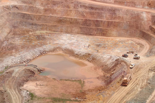
In many cases, villages, agricultural land, and pasturage are displaced as small-scale or artisanal mining operations are replaced by large mines. An interactive overview map created by researchers from the Department of Political and Social Sciences at Freie Universität shows mines and associated conflicts.
Informing Local Residents, Activists, and Journalists
People are forced to leave their villages because new mines are being built there instead. They can no longer use their fields or artisanal gold mining sites, which costs them their livelihoods: The spread of industrial mining leads to many conflicts in Burkina Faso. These kinds of cases are documented in an interactive map developed by Bettina Engels, a junior professor of empirical conflict research who focuses on sub-Saharan Africa, and her colleagues from Freie Universität.
Their goal in creating the map was to give local residents, activists, and journalists an idea of the current situation in Burkina Faso. Engels, a political scientist, knows about it firsthand, as she travels to Burkina Faso regularly for field research. “In theory, the populace is informed about the opening of new mines, but in fact, that is rarely the case. I’ve seen houses marked with white paint, which means people have to vacate their homes, but they don’t know when, or where they are supposed to go.”
Engels explains that because the situation is so confused, and reliable, relevant information is scarce, it is often almost impossible for people to defend themselves. “The law requires mine sites and key data to be announced,” explains Christian Sonntag, a research associate at the Geography Department at Humboldt-Universität, who was among those who developed the map. Nonetheless, he says, mine operators’ websites frequently offer incorrect information or no information at all. This is where the overview map comes in. “If you create a digital map to show where mining is officially authorized, local people can check to see whether a fence is really running in the right place and file complaints if not. Our idea was to prepare information and research findings in a clear, easily understood way and make them generally accessible,” Engels explains.
Map Combines Geodata with Data from Qualitative Social Research
Following this approach, the interactive online map of mine conflicts in Burkina Faso was created in one year. The researchers spent three years before that compiling the data for the map. “Christian Sonntag is the father of the map,” Engels says. A geographer by nature, Sonntag spent months learning programming skills and developing the map, which went live for the public a short while ago.
The map combines geodata with data from qualitative social research. Clicking individual sites opens up information on the situation in a specific region, and users can display images and further research reports. “You can choose between satellite images, landscape images, and a geological display. One thing that was especially important to us was to use open source technology to ensure that the map can truly be displayed anywhere in the world, using any kind of browser,” Sonntag explains. “You can also choose between English and French, so the information is also available to the Francophone population. We update the map on an ongoing basis.”
Positive Responses
The team says the responses to the project from journalists and civil society organizations in Burkina Faso have been very positive. “Our map gives people a bird’s-eye view, which is really appreciated, including by activists who want to gain an overview. The scale of the mines, the giant basins where chemicals are used to extract precious metals from the stone – those things are hard to see and assess from the ground,” Engels says.
Alongside the work done by the four-person team in Berlin, others also helped to realize the project. “A lot of the information and images come from local sources, including graduate students and doctoral candidates on site who are doing research on mine conflicts as well as nongovernmental organizations and private individuals. I couldn’t even tell you how many people are involved in the project,” says Engels. Colleagues from other higher education institutions in Europe have gotten in touch, too. She explains, “They would like to develop a similar map for Ghana, Senegal, or Tanzania, where the situation is very similar.”
Further Information
Bettina Engels, Junior Professor in Empirical Conflict Research focusing on sub-Saharan Africa, Freie Universität Berlin, Tel.: +49 30 838 70989, Email: bettina.engels@fu-berlin.de

