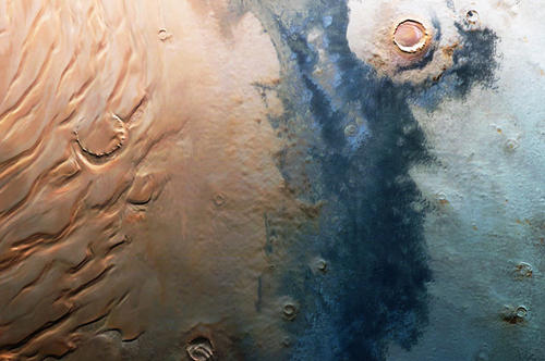
The New Image of Mars
Earth scientists from Freie Universität are working with the German Aerospace Center (DLR) to create a high-resolution map of the surface of Mars.
May 06, 2013
Nearly 90 percent of the surface of Mars has already been surveyed, providing a new basis for our knowledge about the neighboring planet.
Image Credit: ESA/DLR/Freie Universität (G.Neukum)
The now-cooled flows are clearly apparent in the form of rock formations, since alongside its six other measuring instruments, the satellite also carries a high-resolution stereo camera (HRSC) that produces images offering a three-dimensional impression. The goal is to chart the entire surface of Mars at high resolution and in color. The person responsible for heading the project at the German Aerospace Center (DLR) was Professor Gerhard Neukum, who worked in the Planetary Sciences and Remote Sensing unit of the Department of Earth Sciences at Freie Universität Berlin from 2002 until his retirement, in 2012. Nearly 90 percent of the surface of Mars has already been surveyed, providing a new basis for our knowledge about the neighboring planet.
What the probe transmits from space is often hard to imagine here on Earth. For example, Mars is home to the highest mountain in the solar system, Olympus Mons, which rises about 25 kilometers above the plain around it and is thus three times as tall as Mount Everest.
At Freie Universität, Junior Professor Stephan van Gasselt is now responsible for coordinating the work the university has undertaken in analyzing the data. “The mission was actually supposed to run for one Martian year, or about two years on Earth. But since the equipment is still working reliably and European financing is secure, the mission is now in its fifth Martian year.” A year on Mars is twice as long as on Earth because the Red Planet needs nearly 687 days to complete one orbit of the sun.
The working group at Freie Universität prepares the data that the DLR, working in Berlin’s Adlershof district, generates based on the raw material. The researchers merge the mosaic-style images that the orbiter takes in space into a global map while also recording physical information: What kind of rock forms the surface? What climatic conditions predominate there? What interactions are there between the Martian atmosphere and the planet’s surface? The images from space should make it possible to answer these and other questions.
The data arrive at the DLR computing center as bitstreams – a sequence of zeros and ones that does not tell even experts very much without first being prepared via computer programs, van Gasselt explains: “The data first have to be calibrated – that means performing calculations to compensate for deviations caused by the measuring equipment.” Converting the raw image data from the color camera into high-resolution images is a lengthy process. “The onboard camera captures images on nine channels simultaneously,” says van Gasselt, an expert in planetary exploration. We can think of the unit, he says, as a large-scale scanner that captures an area in red, blue, green, and infrared light while also recording it from various angles. The computer can then use these data to calculate 3D images.
The final result is a map of Mars that sets new benchmarks in terms of resolution and coverage. If we think of this in terms of well-known satellite images of the Earth’s surface, that means formations as small as Berlin’s Olympic Stadium or the Reichstag building can be visualized and placed on the global map. “The probe’s cameras can even deliver accuracy of ten to 15 meters per pixel,” van Gasselt says. “But disruptions in the atmosphere and the fact that because of the physical conditions, the probe cannot always maintain the same distance from the surface do not allow such a high resolution everywhere.”
This is especially true since the scientists have to capture and process data on a vast area. The surface of our neighboring planet has about the same area as all the land masses on the Earth put together. The mission was extended for another four years in December 2010, allowing the approximately twelve researchers working on the project at Freie Universität to continue filling in the map with better and better images.
Further Information
-
Prof. Dr. Stephan van Gasselt, Freie Universität Berlin, Institute of Geological Sciences, Planetary Sciences and Remote Sensing, Tel.: +49 30 838-70591, Email: vgasselt@zedat.fu-berlin.de
-
Prof. Dr. Gerhard Neukum, Freie Universität Berlin, Institute of Geological Sciences, Planetary Sciences and Remote Sensing, Tel.: +49 30 838-70579; Email: gerhard.neukum@fu-berlin.de

